Welcome to Aursjøvegen
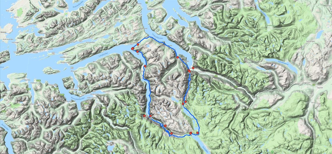
Aursjøvegen (the Aursjø Road) beats most roads in Norway when it comes to spectacular scenery. This mountain road from Sunndalsøra in Sunndal district to Eidsvåg in Molde district extends for 121 km, including a 55-km tolled section originally built in 1947 for construction traffic working on the Aura power station.
The many attractions along the way include towering mountains, well-maintained hiking trails, Aurstaupet viewpoint, Mardalsfossen waterfall, Eikesdalsvatnet lake, the Dovrefjell-Sunndalsfjella national park, rock carvings, mountain dairies, Aursjøhytta lodge, Nesset parsonage. Aursjøvegen invites you to enjoy an unforgetable journey by car, by bike, or on foot!
Dovrefjell–Sunndalsfjella national park
Aursjøvegen is surrounded by the Dovrefjell-Sunndalsfjella national park and the associated conservation areas, which are some of the most important in Norway. So please take great care around nature and wildlife and take your garbage away with you.
From Sunndalsøra, the road follows parts of an old construction railway through Litldalen for 10 km before the toll barrier. Don’t be surprised to see BASE jumpers throwing themselves off precipitous rock faces almost 2,000 meters above sea level. From here, the road climbs steadily up several steep hills. At the top of Hallarvasslia, signs point the way to a fine pothole. It’s hard to believe that our ancestors used to ascend these steep hillsides with their livestock to graze on the alpine pastures in the summer.
At around 800 metres above sea level, Holbuvatnet is the intake reservoir for the Aura power station. From here, the water runs through a 16-km rock tunnel to the generating station at Sunndalsøra. The Holbudammen dam is a good starting point for a hike or a bike ride along the old railway alignment (signposted), which passed Holbuvatnet and continued up to the dam.
Not far from Holbudammen, the Osbumagasinet reservoir originally consisted of several smaller lakes. Aursjøvegen winds its way around the reservoir. Two kilometers beyond Osbudammen, a side road branches off to the east. From this road, a waymarked trail leads to the remains of a 19th-century chromium mine.
Twelve kilometres beyond Osbudammen we reach Torbudalen, where there are many holiday homes, and Torbuvatnet, a lake that has not been harnessed for hydroelectric power. Beside the lake, Torbuvollen seter is a working mountain dairy selling traditional dairy produce. Not far from here, Vikseterplassen Villmarksleir is a wilderness camp offering overnight accommodation. Waymarked trails lead from the camp to former reindeer traps.
Shortly after Torbudalen, the 25 km-long Aursjømagasinet appears. This is the main reservoir for the Aura hydroelectric scheme. Next to the large dam at the end, Aursjøhytta is a cabin belonging to the Kristiansund and Nordmøre Trekking Association and staffed during the summer season. A refreshment stop here is a must.
From Aursjøen the road swings to the northwest, following the Aura river, which hydroelectric development has drained in places. After just over 10 km, you might like to make a detour and follow the signs to Aurstaupet, with its dramatic scenery and great views of Eikesdalen. For many visitors, this is the highlight of the trip – an airy experience is guaranteed.
The last section of Aursjøvegen is perhaps the most spectacular. From an elevation of almost 1,000 meters, the road descends via four hairpin bends and a tunnel to the toll barrier at Finnset, about 200 meters above sea level.
The 56-km section from Finnset to Eidsvåg offers a wealth of sights, the most famous being Mardalsfossen, Northern Europe’s tallest free-falling waterfall. Just before Eidsvåg the road passes Nesset parsonage, where the poet Bjørnstjerne Bjørnson grew up.
Have a pleasant and memorable drive through the mountains!
Aursjøvegen Facts and Figures
- Aursjøvegen opens June 1st and closes when the first snow falls in the autumn.
- Aursjøvegen is a toll road with pay stations located at Litldalen in Sunndal district and Finnset in Nesset district.
- The road’s highest point is at Brønnhø-brøstet, 947 metres above sea level.
- The Sunndal–Aursjøvegen–Eikesdal–Eresfjord–Eidsvåg–Sunndal circular tour is a drive rich in contrasts, with many memorable sights and attractions. The circular tour totals 160 km and is recommended as a day trip. The distance from Sunndalsøra to Eidsvåg via Aursjøvegen is 121 km.
- A number of short, well-marked walking trails lead from the road to places of natural or cultural interest.
- Various establishments offer overnight accommodation, ranging from campsites and rough shelters to hotel standard.
- A number of eating places along the road offer great food and drink.
- Distances from this information board:
Litldalen toll barrier 8 km
Aursjøhytta 44 km
Aurstaupet 55 km
Mardalsfossen 75 km
Eidsvåg 121 km
- For more information please visit Sunndal tourist information centre in Sunndalsøra.
Safety
- The road is not recommended for large coaches or caravans.
- Do not use Aursjøvegen in snowy weather.
- Please drive carefully and consider other road users
Aursjøvegen - map